Satellites: Observing Earth in the new space era

Since their inception almost 70 years ago, satellites have become an indispensable component of our modern high-tech civilization. There are thousands of satellites orbiting the Earth at any given moment today, providing the bandwidth we need to stay online, use our mobile phones, watch cable TV, navigate using GPS, make transactions, and forecast the weather.
In addition to these daily applications, satellites have also taken humanity’s scientific knowledge and technological capabilities to the next level with rapidly evolving data. The most common use for satellite data is Earth observation, or the gathering of information about the Earth’s surface and atmosphere via remote sensing technologies. The use of satellite data and imagery has helped governments and industries make better-informed decisions in areas including agriculture, forestry, urban development, energy, security, and disaster response. Fueled by new innovations, these imaging systems are now being deployed on global missions to monitor pollutants in the atmosphere and mitigate climate change.
This article will provide an overview of different satellites and how they work, and their deployment in the public and private spheres, both at a national and international level.
Satellites 101
Even though satellites are such a vital part of modern life, it’s easy to take them for granted, especially since they’re practically invisible to the untrained eye. Most people also have little knowledge of how satellites work, or how they differ by type and application, but a quick study is all it takes to develop an immense appreciation for the services they provide.
A satellite is a man-made object placed into orbit by a rocket. They can be categorized by their orbit, altitude, and function, and by their utilization in fields including telecommunications, navigation, Earth observation, scientific research, national security, and space exploration. They are self-contained communication systems with the ability to receive and retransmit signals to and from Earth with the help of a transponder, which is an integrated receiver and transmitter of radio signals. They are powered by solar panels, which convert the sun’s energy into electricity. Satellite communication methods and frequencies can vary depending on the satellite’s mission, orbit, and bandwidth requirements, but data is commonly sent through radio waves, microwaves, and laser signals.
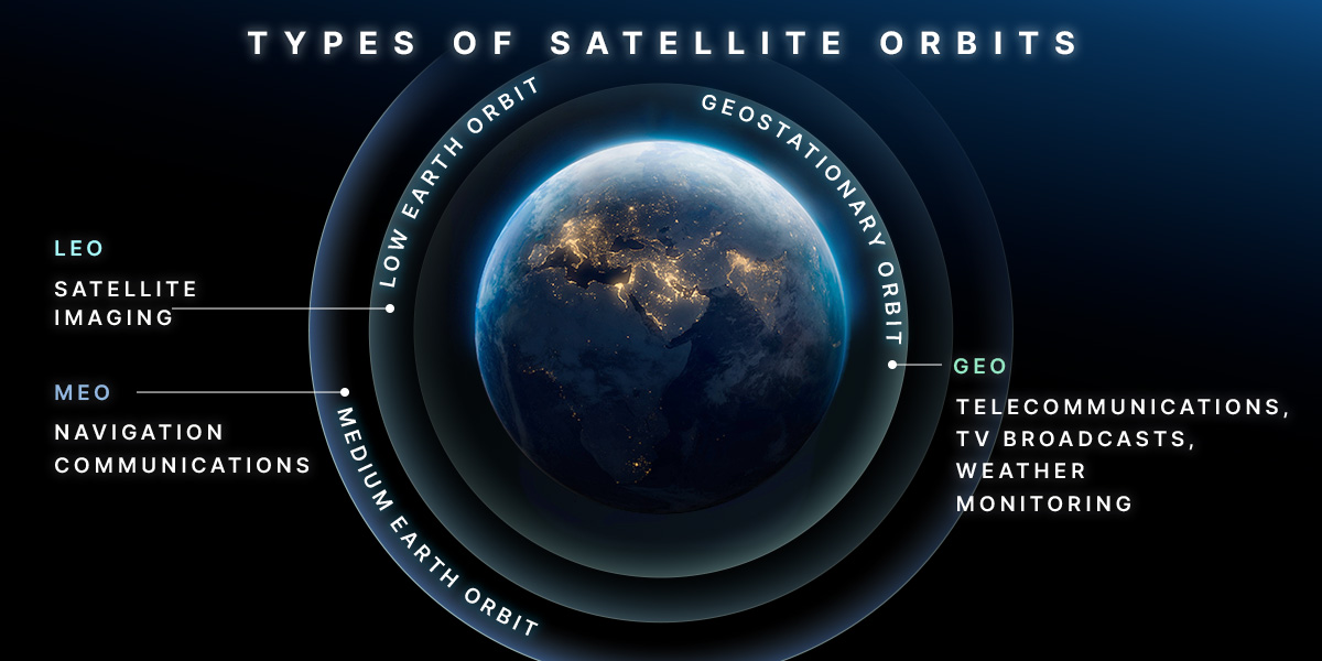
Satellites in geostationary orbit (GEO) circle Earth above the equator, at an altitude of 35,786 kilometers, perfectly matching the Earth’s rotation. As GEO satellites can stay constantly above one place over Earth, they are used for telecommunications, TV broadcasting, and weather monitoring.
Low Earth orbit (LEO) satellites orbit at an altitude of less than 1,000 km and their orbit plane can be tilted, meaning there are more routes available for these satellites compared to those in GEO. The proximity to Earth makes LEO satellites useful for satellite imaging, as being near the surface allows them to take high-resolution images. LEO satellites often work as part of a large constellation, launched together to create a “net” around Earth. This means they can cover large areas of Earth simultaneously by working together.
Medium Earth orbit (MEO) comprises a wide range of orbits between LEO and GEO. MEO satellites are commonly used by navigation satellites, like the European Galileo system, which powers navigation communications across Europe.
In addition to providing signals and satellite imagery needed for day-to-day life, satellites also provide data that helps us better understand our planet. Earth observation data has a wide range of applications, from risk management, disaster assessment, environmental impact evaluation, and urban analysis to providing increased awareness and military intelligence in peace operations.
Earth observation satellites in use worldwide
Earth observation refers to the use of remote sensing technologies to monitor large areas of land, sea, and atmosphere. Most of this data comes from spaceborne platforms with remote sensing tools. For observation through satellites, data is collected through a passive or an active remote sensing system.
A passive remote sensing system delivers data only in sunlit, cloudless circumstances using optical and thermal sensors. Active remote sensing, meanwhile, uses radar and laser technologies, and includes two types of radar-based systems — real aperture radar (RAR) and synthetic aperture radar (SAR). This distinction is important as SAR is the only instrument that can penetrate clouds and doesn’t require sunlight to provide reliable remote sensing data. This is what makes SAR satellites the preferred type of Earth observation LEO satellite for generating high-resolution images of the Earth’s surface. SAR satellites can take imagery any time of night or day, making it possible to collect and archive consistent, long-term data for numerous applications.
Notable SAR satellites used at the national level include the European Space Agency’s Sentinel-1A and Sentinel-1B. These satellites have been used for flood monitoring, oil spill assessment, maritime surveillance, and Antarctic ice shelf monitoring.
At the private level, several companies operate SAR satellite programs to provide solutions for government and commercial use. In the U.S., Capella Space, an aerospace company providing Earth observation data on demand, became the first American company to develop, launch, and operate a commercial SAR satellite in 2018. In Korea, Hanwha is a comprehensive provider of satellites with both electro-optic (EO), infrared (IR), and SAR as part of its overall strategy of providing end-to-end solutions that cover satellite development, space monitoring, and image analysis.
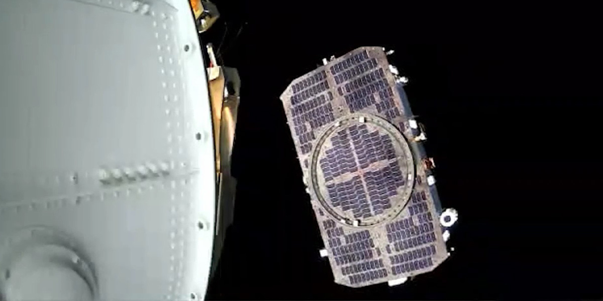
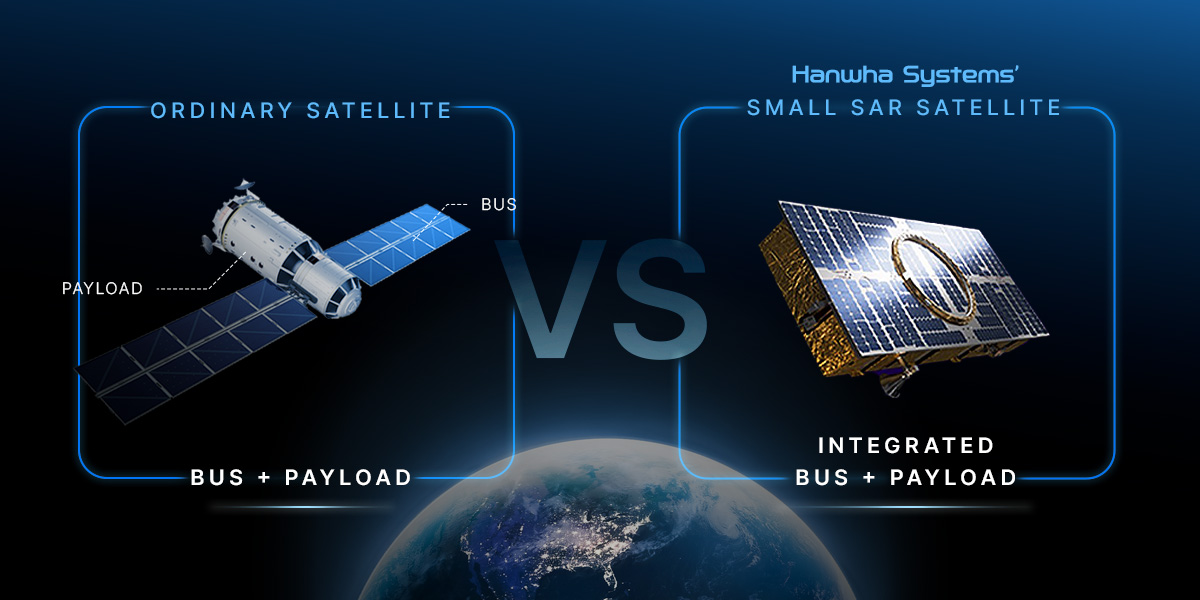
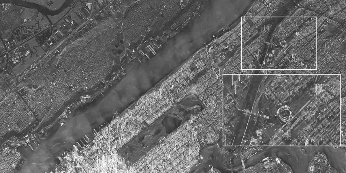
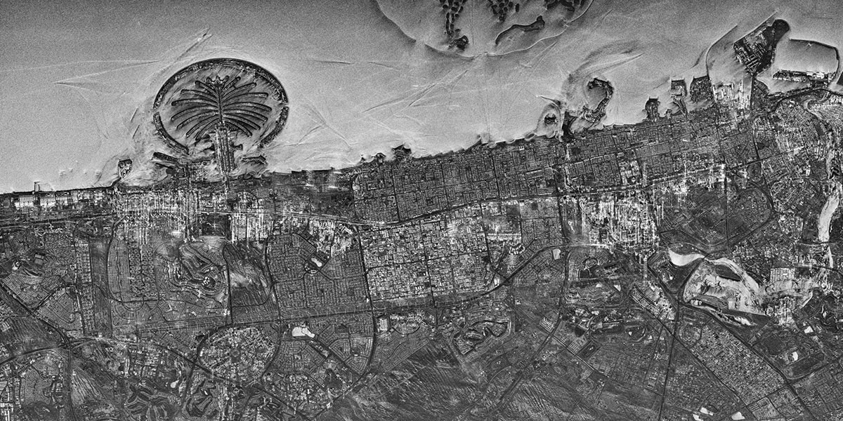
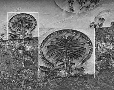
Hanwha Systems is preparing a business not only for satellites, but also for satellite controls, ground station operations, satellite imagery analyses and distribution. As part of its continued efforts to innovate and improve its satellite technology and applications, Hanwha Systems released high-resolution images of Earth’s major landmarks last month sent by its small SAR satellite that has been in orbit since last December. This satellite delivers 1-meter resolution images from an altitude of 650 kilometers above Earth, showing major bridges, rivers, and airports in detail. Veering away from conventional satellite design, it has a unique shape that integrates its payload, main body, and solar panels to maximize the available loading space on the launch vehicle. Going forward, the company has plans to create diverse value-added services in the satellite service market, including image analysis for environmental monitoring, and data analysis for geographic information system (GIS) mapping.
Meanwhile in Daejeon, Korea, Satrec Initiative — whose largest shareholder is Hanwha Aerospace — is developing SpaceEye-T, a very high resolution satellite set for launch in 2025. If successful, Korea will become the fifth country to have such a satellite in orbit, after the U.S., France, Israel, and China. The images from the satellite will be used in a wide range of applications including space-based intelligence, surveillance, and reconnaissance (ISR), mapping, disaster monitoring, autonomous driving, and land management.
Observing our future
Satellites, with their versatile applications, have revolutionized life on Earth, and will continue to do so thanks to the technological advances made by public and private players alike. While Earth observation satellites serve varying purposes, at the international level, they have zoomed in on a pressing issue affecting all those who call this planet home — climate change.
The European Union has been monitoring the atmosphere using the TROPOspheric Monitoring Instrument (TROPOMI) since 2017, using satellites that can distinguish between anthropogenic and natural CO2 to track human-sourced emissions. The EU’s Copernicus Earth Observation program is also preparing a constellation of three satellites scheduled to launch in 2025 that will play a role in hitting emission reduction targets of the Paris Agreement.
This March, SpaceX launched an Earth observation satellite that Google will use to map methane from space. The satellite, called MethaneSAT, was developed by the Environmental Defense Fund (EDF), a non-profit global climate group, to monitor and study global methane emissions. Google will use the data provided by MethaneSAT combined with AI to map methane leaks worldwide, which are a critical driver of climate change.
As climate change can affect crops, soil and water resources, and rural communities, Satrec’s Earth observation satellite, as well as Hanwha Systems’ SAR and IR satellites, are being operated at the private level for agricultural land monitoring and yield estimation. The data collected will help to to predict annual flood occurrence and oil prices as communities worldwide grapple with extreme weather patterns and related risks.
At the dawn of the new space era, the constellation of satellites in our atmosphere will not only serve as our data centers that inform our monitoring activities and risk assessments, but they will also shape our practices as the world transitions to net zero. Satellites will help take humanity further into space, but also put the state of our planet into perspective and bring nations together for collaborative action.


Get the latest news about Hanwha, right in your inbox.
Fields marked with * are mandatory.
- Non-employee
- Employee