What’s in a number: 6 figures that reveal the power of Earth observation

Wildfires, shifting fault lines, damaged roads, and urban sprawl.
Earth observation (EO) satellites track it all — and more — in real time and high resolution. They replace guesswork with hard data from orbit, helping experts across sectors monitor change, act quickly, and plan with confidence.
Orbiting just a few hundred kilometers above the planet, EO satellites are equipped with advanced sensors that capture high-resolution images of our planet. From coastlines and croplands to cities and conflict zones, they provide a clear, timely view of global activity.
Whether it's monitoring disasters, tracking deforestation, or supporting agriculture, EO satellites have become critical across industries. Their true value lies in enabling smarter, faster decisions in a world that never stops moving.
One of the latest additions to this rapidly growing sector is SpaceEye-T, a high-resolution EO satellite developed by Satrec Initiative, with Hanwha Aerospace as the largest shareholder. Featuring industry-leading resolution and next-gen imaging capabilities, SpaceEye-T reflects both the pace of innovation and rising global demand for commercial satellite solutions.
Let’s explore six key figures that show why EO matters — and how technologies like SpaceEye-T are shaping the future of space-based insight.
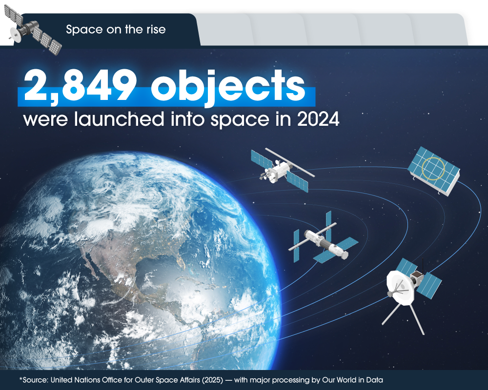
In 2024, 2,849 objects — including satellites, probes, and crewed spacecraft — were launched into orbit and beyond. A decade earlier, in 2014, that number was just 241. This dramatic rise reflects how the space industry is evolving — driven by growing commercial activity, national investment, and an expanding range of satellite applications, as well as a growing need to manage space as shared infrastructure.
Space is shifting from exploration to infrastructure, supporting everything from global navigation to environmental monitoring.
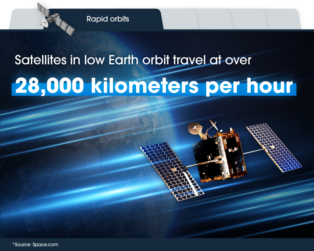
Low Earth orbit (LEO) is home to satellites flying 2,000 kilometers (1,243 miles) above the planet or less. Travelling at around 28,000 kilometers per hour (17,500 miles per hour), a satellite can cross the entire U.S. in just 10 minutes. This speed allows LEO satellites to circle Earth roughly every 90 minutes — providing frequent, near real-time coverage. That revisit rate is key to why EO satellites are so effective at monitoring Earth’s surface as it changes, day after day.

EO data is becoming a powerful economic driver, with applications expanding across infrastructure, agriculture, energy, and more. According to the World Economic Forum, EO could contribute up to $3.8 trillion to global GDP between 2023 and 2030. It’s a sign not just of the value of space-based insight but of its growing role in driving smarter decisions across industries worldwide.

By 2032, EO satellites are expected to generate 2 exabytes of data — that’s 2 billion gigabytes of imagery, measurements, and environmental signals. Turning this vast volume into usable insight requires advanced technologies like AI, edge computing, and geospatial modeling — helping industries process, analyze, and act on data faster than ever. These capabilities support more efficient, data-driven decisions across sectors — driving meaningful impact in the real world.

By enabling smarter land use, infrastructure planning, and emissions monitoring, EO helps governments and industries drive measurable climate action. In fact, EO data could support a reduction of 2 gigatons of greenhouse gas emissions annually — roughly 3.6% to 3.8% of current global emissions, or the equivalent of taking 435 million cars off the road. That’s nearly a third of all passenger vehicles worldwide.
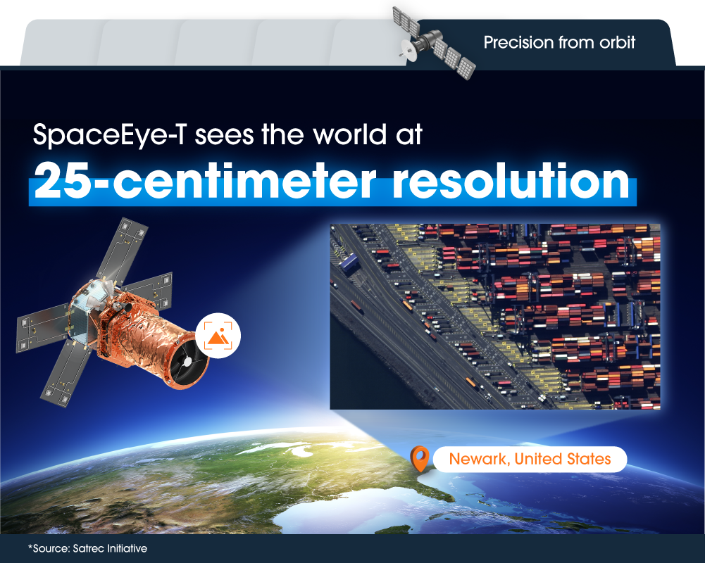
Launched in March 2025, SpaceEye-T brings extraordinary clarity to EO, capturing details as small as 25 centimeters (9.8 inches) from orbit — sharp enough to distinguish road markings, vehicle types, and small structures. That level of precision places it among the highest commercially available resolutions in EO today. Developed by Satrec Initiative, SpaceEye-T reflects Hanwha’s growing role as a full-spectrum EO solutions provider, delivering sharper, more actionable insights from space.
Related Content


Get the latest news about Hanwha, right in your inbox.
Fields marked with * are mandatory.
- Non-employee
- Employee